Ancient roads and tracks are important features of archaeological landscapes because they reveal how people moved between settlements, agricultural areas, markets, religious centers, and sources of raw materials. Some routes remain visible as paved surfaces, embankments, or deep hollow ways, while others have disappeared beneath soil, vegetation, modern development, or agricultural fields. In these situations, geophysical survey can help archaeologists investigate possible routes without excavating the entire landscape. Magnetic survey is one method that may reveal buried features associated with roads, although its effectiveness depends on the materials used to construct the route and the surrounding soil conditions.
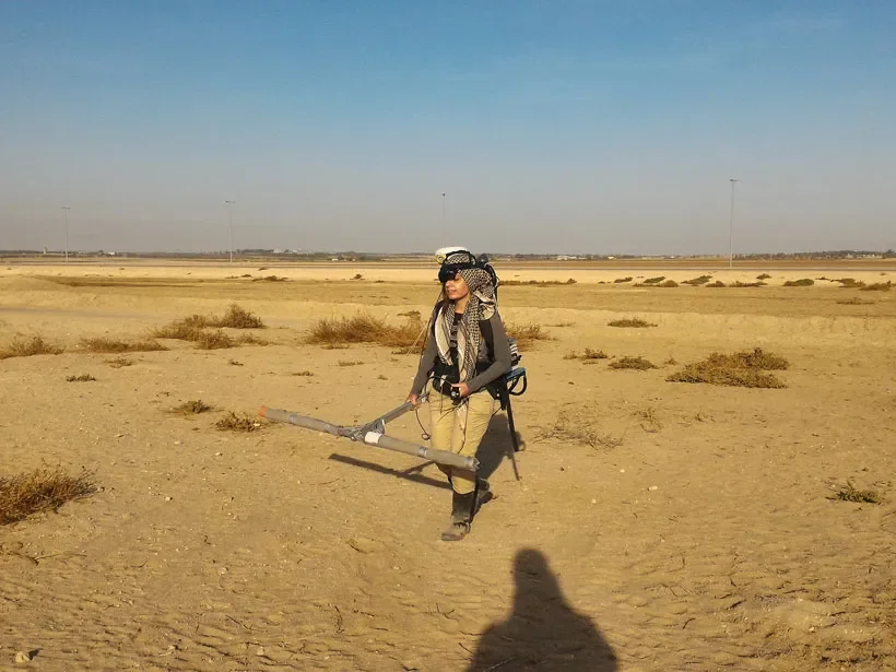
Magnetic survey measures small variations in the magnetic properties of the ground. Different soils and archaeological materials can produce different magnetic signals, allowing instruments to detect contrasts that are not visible at the surface. Certain human activities, including burning, the accumulation of organic waste, and the deposition of iron-rich materials, can alter the magnetic properties of soil. Archaeological features such as ditches, pits, hearths, and some types of construction may therefore produce recognizable anomalies. However, a magnetic anomaly is not a direct image of an ancient object. It is a measured variation that requires interpretation in relation to the local geology and archaeological context.
Buried roads can create magnetic signals in several ways. A road surface may contain stone, gravel, clay, or other materials that differ magnetically from the surrounding soil. Construction may also have involved digging shallow ditches, removing topsoil, or laying layers of prepared sediment. Over time, these features could develop contrasts with adjacent deposits. In other cases, traffic may have compacted the ground or altered drainage, indirectly affecting the formation of soil layers. The magnetic response of a road therefore depends not only on its original construction but also on the environmental and human processes that occurred after it was abandoned.
The materials used to build a road strongly influence its detectability. A track made primarily from ordinary stone may produce little magnetic contrast if the stone has similar properties to the local geology. A road surface containing fired materials, iron-rich sediment, or debris from nearby activity may generate a stronger signal. Nearby hearths or workshops can also create magnetic patterns that overlap with a route, making interpretation more difficult. Consequently, the absence of a magnetic anomaly does not prove that an ancient road is absent, and a strong anomaly does not necessarily indicate a road.
Survey design is essential when investigating possible routes. Archaeologists may collect magnetic measurements across a broad area to identify linear patterns, then examine promising locations at a higher resolution. A road may appear as a long, narrow feature, although its signal can be interrupted by later disturbances or variations in construction. The direction and continuity of the anomaly can help researchers determine whether it is consistent with a route. Comparisons with topography, aerial photographs, historical maps, and other geophysical methods can provide additional evidence.
The landscape setting of a suspected road is particularly important. Ancient routes often followed terrain that made movement easier, connecting valleys, passes, river crossings, or areas with relatively gentle slopes. A linear magnetic anomaly that follows a plausible corridor may be worth investigating, especially if it connects known archaeological sites. However, natural geological boundaries, modern field drains, pipelines, and recent agricultural features can also produce linear patterns. Researchers must identify and exclude these alternatives before interpreting an anomaly as an ancient track.
Ground-penetrating radar and electrical resistance survey can complement magnetic methods. Ground-penetrating radar sends electromagnetic pulses into the ground and records reflections from subsurface boundaries, potentially revealing changes in the structure of a buried road. Electrical resistance survey measures how easily electrical current passes through the soil, which can vary with moisture content and material composition. These techniques respond to different physical properties, so combining them can provide a more complete picture of a suspected feature. The best method depends on soil conditions, depth, moisture, the expected construction materials, and the research question.
Remote sensing can also contribute to the detection of ancient routes. Aerial imagery, satellite photographs, and elevation models may reveal crop marks, soil marks, embankments, or subtle depressions associated with former roads. Under certain conditions, vegetation grows differently above buried features because they affect soil depth, drainage, or nutrient availability. Light and shadow can reveal shallow relief that is difficult to see from ground level. These methods can identify possible route corridors over large areas, while geophysical survey helps investigate the nature of the subsurface features.
The interpretation of a magnetic anomaly requires particular caution because archaeological landscapes often contain several overlapping phases of activity. A road may have been constructed along an older path, repaired repeatedly, and later crossed by buildings or field boundaries. Modern ploughing can damage the original surface and redistribute material across the site. A magnetic pattern may therefore represent several periods rather than a single ancient road. Researchers need to consider the chronology of nearby features and, where necessary, use limited excavation to establish the sequence of construction and reuse.
Dating a buried road is difficult because the road surface itself may contain few objects that can be dated directly. Artifacts embedded within a construction layer can provide a chronological indication, but they may have been collected from older deposits or introduced during later repairs. Material found in a ditch beside the road may date the filling of the ditch rather than the original construction of the route. Radiocarbon dating of suitable organic remains may help establish a chronological range, while stratigraphic relationships can clarify whether the road predates or postdates nearby structures.
The broader significance of an ancient road depends on how it fits into the surrounding settlement system. A route connecting several sites may have supported trade, migration, seasonal movement, military travel, or access to agricultural resources. Yet a road's physical size does not automatically reveal its purpose. A substantial route may have served local traffic over a long period, while a narrow track could have connected important regional destinations. Researchers examine the distribution of settlements, artifacts, resource locations, and other transport features to investigate how people used the route.
Magnetic survey is valuable because it allows archaeologists to investigate possible ancient roads across large areas with limited physical disturbance. Its greatest strength lies in identifying patterns that can guide further research, rather than providing a definitive answer on its own. By combining magnetic anomalies with terrain analysis, other geophysical methods, remote sensing, and carefully targeted excavation, researchers can reconstruct buried routes and explore how movement shaped ancient landscapes. The results can reveal not only where people traveled but also how roads connected settlements, resources, and communities across time.