Rock shelters have served as places of refuge, temporary camps, working areas, and repeated gathering sites for human communities over thousands of years. Their natural protection from rain and wind makes them especially valuable for archaeological research, as deposits can accumulate beneath overhanging rock and preserve traces of past activity. Among these traces, soot deposits on ceilings and walls can provide information about the use of fire and the changing intensity of human occupation. When mapped carefully, soot layers may help researchers reconstruct how people used a shelter over time and whether particular activities were associated with different seasons.
Soot forms when combustion produces fine carbon-rich particles that become deposited on nearby surfaces. The amount and composition of soot depend on the type of fuel burned, the efficiency of combustion, ventilation, and the distance between the fire and the rock surface. Wood, grasses, animal dung, and other combustible materials can produce different patterns of smoke and residue. A fire burning beneath a low ceiling may leave a concentrated dark patch, while a fire in a more open area may disperse smoke across a wider surface. These differences can help researchers investigate how fire was used within a shelter, although the relationship between a soot patch and a specific activity is not always straightforward.
Mapping soot begins with documenting its location, thickness, color, and relationship to the shelter's architecture. Researchers may record whether the deposits occur near the entrance, deeper inside the shelter, above a hearth, or along a particular section of the ceiling. High-resolution photographs and three-dimensional models can preserve the spatial pattern for later comparison. In some cases, microscopic sampling may reveal differences between layers that appear similar to the naked eye. These records can help establish whether soot accumulated gradually or whether several episodes of burning produced distinct deposits.
One of the main challenges is determining how many fires contributed to a soot layer. A darkened ceiling may represent repeated fires over many years rather than a single period of occupation. Later fires can add new material over older deposits, while cleaning, erosion, or natural weathering may remove portions of the original soot. The visible thickness of a deposit therefore does not provide a direct measure of how long a shelter was occupied. Researchers need to compare the soot with archaeological layers on the floor, hearth remains, charcoal, and other evidence of human activity.
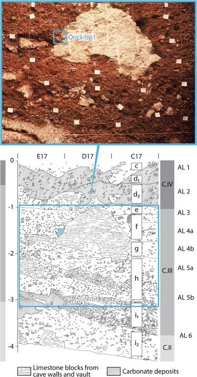
Stratigraphy can provide a useful chronological framework. If a hearth is associated with a clearly defined occupation layer, charcoal from that context may help date the activity, subject to the limitations of the sample. Soot layers on a ceiling are more difficult to date directly because carbon particles may accumulate over several separate events. In some circumstances, researchers may compare soot chemistry or microscopic structure across different areas, but these similarities must be interpreted cautiously. A soot layer that appears continuous may have developed at different times in separate locations, while visually distinct layers may have formed during closely spaced episodes of activity.
Seasonal interpretation is especially challenging because soot does not inherently record the season in which a fire was made. A large concentration of soot could reflect prolonged occupation during cold weather, but it could also result from poor ventilation, the use of smoky fuel, or repeated cooking in the same location. To investigate seasonal use, archaeologists need independent evidence that can be connected to particular times of year. Animal remains may indicate whether people hunted or processed species available during specific seasons. Plant remains, seeds, and other botanical evidence may help identify seasonal gathering or harvesting activities. The age and development of certain animal remains can also contribute to seasonal estimates, although the precision depends on the species and the preservation of the evidence.
Environmental records can further strengthen these interpretations. Pollen, phytoliths, charcoal, and other microscopic remains may reveal changes in vegetation around the shelter. Some plant species flower or produce seeds at particular times of year, while others respond to longer-term environmental shifts. Researchers must distinguish seasonal patterns from broader changes in climate and vegetation. A change in the types of plants represented in a shelter deposit may reflect a different season of occupation, but it could also indicate a shift in fuel selection, food preparation, or the surrounding landscape.
The position of hearths within a shelter can reveal changes in how people organized their activities. Fires placed near entrances may have benefited from ventilation, while fires deeper inside could have provided greater protection from wind and cold. However, smoke management would have been important in enclosed spaces, and occupants may have adjusted the position of their fires depending on weather conditions and the number of people present. If soot patterns repeatedly concentrate above certain areas, researchers may investigate whether these spaces were regularly used for cooking, heating, or other fire-related tasks. These interpretations become stronger when soot distribution corresponds with hearths, tools, food remains, or activity surfaces.
Repeated visits can complicate the archaeological record. A shelter may have been used by different groups for different purposes, with long periods separating episodes of occupation. One group may have used it as a short-term hunting camp, while another later used the same space for storage, cooking, or shelter during travel. The soot deposited during these separate visits may overlap, creating a palimpsest of activity. Archaeologists must therefore avoid assuming that all evidence found within one shelter belongs to a single community or period.
Natural processes also influence soot preservation. Water entering the shelter can wash away deposits or carry particles across the rock surface. Wind may transport dust that becomes mixed with soot, while mineral growth can cover older deposits. In some cases, biological growth or modern fires may alter the appearance of the rock. Researchers need to distinguish ancient soot from more recent contamination, especially in shelters that continue to be used by local communities or visitors. Comparing deposits with nearby surfaces and examining their relationship to known archaeological layers can help establish their likely origin.
Soot mapping offers a way to connect small traces of combustion with broader questions about mobility, settlement, and daily life. When combined with hearth analysis, environmental evidence, artifact distributions, and secure dating, soot patterns can help researchers understand how people occupied rock shelters and how their activities changed over time. Seasonal use remains a hypothesis that must be tested rather than inferred from darkness or thickness alone. A careful, multidisciplinary approach can reveal whether a shelter was used intermittently, occupied repeatedly during particular conditions, or adapted to changing needs across many generations.