Introduction
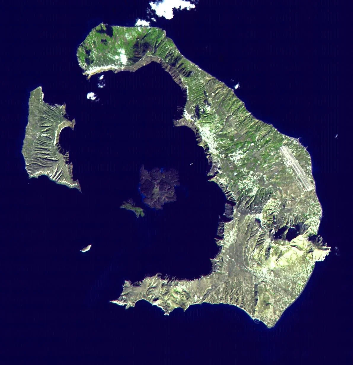
Santorini is one of the most geologically remarkable islands in the Mediterranean. Its dramatic cliffs, volcanic islands, submerged caldera, and history of major eruptions make it an important location for geological research.
The concept of Satellite Maps of Santorini Caldera Shifts explores how satellite technology can help scientists observe changes in the island's surface and monitor geological activity beneath the Aegean Sea.
Satellite monitoring is already an important part of modern volcanology. Researchers can use radar imagery, optical observations, and positioning systems to detect ground deformation and identify changes that may indicate volcanic or tectonic activity.
The Formation of Santorini's Caldera
Santorini belongs to the South Aegean Volcanic Arc, a chain of volcanic systems associated with the subduction of the African Plate beneath the Aegean region.
Its present landscape was shaped by multiple volcanic events.
One of the most significant was the Late Bronze Age eruption, often associated with the Minoan civilization. This enormous eruption transformed the island and contributed to the formation of its distinctive caldera.
The caldera is now partially flooded by the sea, with steep cliffs surrounding its central basin.
What Satellite Mapping Reveals
Satellites can observe the Earth's surface repeatedly over large geographical areas.
Optical imagery helps researchers identify changes in coastlines, vegetation, construction, and surface conditions.
Radar satellites provide another important capability. They can collect information through cloud cover and during nighttime.
By comparing radar observations taken at different times, scientists can identify subtle changes in the distance between the satellite and the ground.
Interferometric Synthetic Aperture Radar
One of the most useful techniques is Interferometric Synthetic Aperture Radar, commonly known as InSAR.
The method compares radar signals collected during different satellite passes.
Small changes in the signals can reveal ground movement, including uplift or subsidence.
In volcanic environments, this information can help researchers identify deformation associated with changes in underground pressure, magma movement, hydrothermal activity, or tectonic processes.
However, radar measurements require careful interpretation because atmospheric conditions and surface changes can affect the results.
Monitoring the Caldera
Santorini's volcanic system includes Nea Kameni and Palea Kameni, islands located within the caldera.
Researchers have studied deformation in the area using satellite observations and ground-based instruments.
During periods of unrest, measurements can help determine whether the ground is expanding, contracting, or remaining relatively stable.
These observations are especially useful when combined with seismic monitoring, GPS measurements, and geological fieldwork.
The Importance of the 2011–2012 Unrest
Santorini experienced a period of increased seismic and deformation activity during 2011 and 2012.
Scientific monitoring identified changes in the volcanic system, including measurable ground displacement.
The episode demonstrated the value of combining satellite observations with instruments installed directly on the islands.
It also showed why deformation should not automatically be interpreted as an imminent eruption. Volcanic systems can experience changes without progressing toward an eruption.
Mapping Underwater Structures
Satellite imagery cannot directly provide a complete map of the submerged caldera floor.
For underwater geological mapping, researchers use methods such as multibeam sonar, marine seismic surveys, and remotely operated underwater vehicles.
These technologies can reveal underwater topography, volcanic deposits, and geological structures.
Combining satellite observations with marine surveys creates a more complete understanding of the volcanic system.
Public Safety and Scientific Communication
Satellite maps can support hazard assessment, but they are not standalone eruption prediction tools.
Scientists must compare multiple types of evidence before interpreting changes in volcanic activity.
Public communication is equally important.
Clear explanations can help residents, visitors, and authorities understand the difference between ordinary geological variation and signs requiring additional attention.
Conclusion
Satellite Maps of Santorini Caldera Shifts demonstrate how space-based technology has transformed the study of active volcanoes.
Satellite radar can detect subtle surface movements, while optical imagery and marine surveys provide additional geological information.
The greatest scientific value comes from combining these observations with seismic instruments, GPS networks, and field research.
Santorini's volcanic landscape remains an important natural laboratory for understanding how Earth's crust changes over time and how modern technology can improve volcanic monitoring.