Introduction
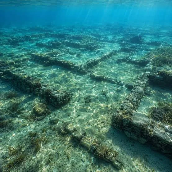
Beneath the waters near the southern coast of Laconia lies one of the most fascinating archaeological sites in the Mediterranean: Pavlopetri.
The submerged settlement is widely recognized for its remarkably preserved ancient urban layout, including streets, buildings, courtyards, and other architectural features.
The idea of AR Tours of Submerged Pavlopetri Streets explores how augmented reality could allow visitors to experience this underwater settlement without disturbing its fragile remains.
Although augmented reality can create compelling educational experiences, a permanent, fully operational AR tour of the submerged streets should not be assumed to exist without specific documentation.
The Archaeological Importance of Pavlopetri
Pavlopetri is located near the coast of southern Laconia, close to the modern village of Pounta and the island of Elafonisos.
The site is generally associated with Bronze Age occupation, although its chronology and development have been subjects of archaeological investigation.
Its underwater remains include structures interpreted as buildings, streets, courtyards, and other elements of an organized settlement.
The site provides valuable evidence for ancient coastal life and settlement planning.
How the Settlement Became Submerged
The submergence of Pavlopetri is associated with long-term geological and environmental changes.
Relative sea-level changes, tectonic movement, and coastal processes have affected the region over thousands of years.
The exact history of submergence is complex and should not be reduced to one sudden event.
Archaeologists and geologists use dating evidence, geological observations, and underwater surveys to reconstruct the transformation of the ancient coastline.
What Is Augmented Reality?
Augmented reality, or AR, combines digital information with a view of the real world.
Unlike virtual reality, which generally places users inside a fully computer-generated environment, AR adds digital objects to the user's surroundings.
A visitor using a phone, tablet, or specialized headset could potentially see reconstructed buildings positioned over the actual underwater site.
The experience might include labels, historical explanations, architectural outlines, and animated reconstructions.
Reconstructing Ancient Streets
An AR reconstruction would require accurate archaeological data.
Researchers would first create detailed maps of the submerged structures using underwater surveying techniques.
Photogrammetry, sonar mapping, and three-dimensional scanning can help record the site.
Digital models could then be used to reconstruct buildings and streets based on surviving foundations and archaeological interpretation.
Missing sections would need to be clearly identified as hypothetical rather than presented as confirmed features.
A Possible Visitor Experience
An AR tour could begin at a visitor center on the coast.
Visitors might view a digital map showing the ancient settlement's location and layout.
A mobile application could then display reconstructed buildings, explain the function of different spaces, and compare the ancient coastline with the modern landscape.
For people who cannot enter the water, an indoor AR installation could offer an accessible alternative.
Underwater Technology
Direct underwater experiences would require additional equipment.
Divers could potentially use waterproof tablets or specialized display systems, although practical limitations include visibility, battery life, water conditions, and safety.
Another option would involve surface-based AR, using cameras or digital maps to overlay reconstructions onto live views of the underwater site.
Such systems would need careful calibration to ensure that digital structures align correctly with the archaeological remains.
Conservation and Responsible Tourism
Pavlopetri is an archaeological site of international importance.
Increased tourism could create risks through accidental contact, sediment disturbance, anchoring, and uncontrolled underwater activity.
An AR experience could reduce some of these pressures by allowing visitors to explore the site digitally without physically entering sensitive areas.
Conservation authorities would still need to manage access and establish clear visitor rules.
The Educational Potential
AR could make archaeological research more understandable.
Instead of looking at disconnected underwater foundations, visitors could see how the settlement may have functioned as a living community.
The technology could explain ancient domestic architecture, coastal trade, water access, and settlement organization.
It could also demonstrate how archaeologists distinguish direct evidence from reconstruction.
Conclusion
AR Tours of Submerged Pavlopetri Streets offer an exciting possibility for combining archaeological conservation with immersive digital education.
Pavlopetri's underwater remains provide a strong foundation for three-dimensional mapping and historical reconstruction.
A responsible AR experience would make the ancient settlement accessible while protecting the physical site.
The most valuable result would be a digital interpretation that allows visitors to understand the settlement's layout, appreciate its archaeological significance, and recognize the difference between what survives underwater and what researchers are reconstructing.