Introduction
Olive cultivation is deeply connected to the agricultural history and cultural identity of Crete. For centuries, olive trees have shaped the island's landscapes, rural settlements, cuisine, and economy.
Traditional olive farming often takes place on sloping terrain where trees grow across terraces constructed to manage soil and water.
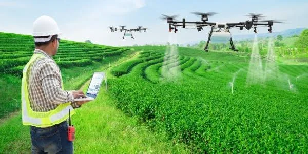
The title AI Olive Drones Over Crete Terrace Farms explores how artificial intelligence, unmanned aerial vehicles, and agricultural sensors could help farmers manage olive groves more efficiently.
Although drone-based agricultural monitoring is already an established technological field, the use of AI systems across specific Cretan terrace farms should be evaluated according to actual deployments rather than assumed to be universal.
The Importance of Olive Cultivation in Crete
Crete is one of Greece's important olive-producing regions.
Olive trees are cultivated across different elevations and landscapes, from coastal plains to mountainous agricultural terraces.
The island's Mediterranean climate supports olive production, although rainfall patterns, temperature, soil conditions, and water availability influence annual yields.
Olive cultivation is also closely tied to local knowledge.
Farmers understand individual trees, seasonal conditions, pruning requirements, and the characteristics of their land.
Modern agricultural technology can support this knowledge rather than replace it.
Why Use Drones in Olive Farming?
Drones can capture aerial images of agricultural land quickly and repeatedly.
Traditional field inspections require farmers to walk through individual groves.
This can be difficult when farms are spread across steep slopes or divided into small terraces.
A drone can survey large areas and identify differences in vegetation, canopy density, and visible signs of stress.
When combined with appropriate sensors and analytical software, aerial images can provide information that may not be obvious from ground level.
Artificial Intelligence and Image Analysis
Artificial intelligence can analyze images to identify patterns.
Machine-learning systems may be trained to recognize changes in leaf color, canopy structure, tree density, or other visual indicators.
For example, an AI model could compare images collected at different times and identify trees that appear less vigorous than surrounding trees.
This could help farmers decide where to conduct closer inspections.
However, image analysis does not always reveal the exact cause of a problem.
A tree with unusual leaf coloration could be affected by drought, disease, nutrient deficiency, pests, or natural seasonal changes.
Ground inspection and additional testing remain important.
Multispectral and Thermal Imaging
Ordinary drone cameras capture visible light.
More advanced systems can use multispectral sensors to record wavelengths beyond the visible spectrum.
These measurements can help estimate vegetation characteristics and identify areas experiencing stress.
Thermal cameras measure surface temperature.
In agricultural applications, temperature patterns may provide clues about water stress or differences in plant condition.
However, sensor data must be interpreted carefully.
Weather, sunlight, wind, soil exposure, and the timing of image collection can influence readings.
Managing Irrigation on Terraced Land
Terraced farms present distinctive water-management challenges.
Water can move differently across slopes depending on soil depth, terrace construction, drainage, and vegetation.
Some trees may receive sufficient moisture while others experience stress.
Drone imagery can help identify areas that deserve inspection.
Farmers could combine aerial information with soil-moisture sensors and local weather data to plan irrigation more efficiently.
This may be particularly valuable during dry periods when water resources are limited.
Detecting Pests and Disease
Olive trees can be affected by different pests and diseases.
One important example is the olive fruit fly, which can damage developing olives and reduce the quality of harvested fruit.
AI-assisted monitoring could help identify changes in tree appearance or fruit conditions that warrant further inspection.
However, aerial imagery alone cannot reliably diagnose every pest or disease.
A useful system would combine drone observations with field scouting, insect traps, weather information, and laboratory diagnosis where necessary.
Predicting Harvest Conditions
Drone imagery may also contribute to estimates of canopy size, tree condition, and possible fruit production.
When combined with historical yield records and weather data, machine-learning models can help estimate harvest potential.
Such estimates could support decisions about labor, harvesting schedules, transportation, and storage.
Nevertheless, olive yield prediction is complicated.
Flowering success, fruit development, weather events, pests, and harvest timing all influence the final crop.
AI predictions should therefore be treated as decision-support tools rather than guaranteed forecasts.
Terrace Preservation and Soil Management
Olive terraces are not merely agricultural platforms.
They are part of the island's historical landscape and can help reduce soil erosion.
Poorly maintained terraces may experience wall collapse, water runoff, and soil loss.
Drone mapping can help document terrace boundaries, damaged walls, drainage channels, and vegetation changes.
Three-dimensional terrain models may also help farmers and conservation specialists assess erosion risks.
This creates an opportunity to combine modern agricultural technology with the preservation of traditional rural landscapes.
Challenges of Drone Adoption
Drone technology has practical limitations.
Equipment can be expensive, and farmers may need training to operate it safely.
Battery life, weather, steep terrain, and signal coverage can affect operations.
Data processing also requires appropriate software and technical knowledge.
European and Greek aviation rules may restrict where and how drones can be operated.
Farmers must also consider privacy when aerial surveys include nearby homes or private property.
A Future for Precision Olive Farming
A practical precision-agriculture system for Crete could combine drones, ground sensors, weather stations, satellite imagery, and farm-management software.
Drones would collect high-resolution information.
AI systems would identify patterns.
Ground sensors would provide measurements of soil and environmental conditions.
Farmers would use the combined information to make decisions about irrigation, inspection, pruning, and harvesting.
The best systems would be affordable, reliable, and adapted to the size and structure of local farms.
Conclusion
The AI Olive Drones Over Crete Terrace Farms concept illustrates how traditional agriculture could benefit from modern technology.
Drones and AI can help monitor tree health, identify unusual patterns, support irrigation planning, estimate harvest conditions, and document terrace landscapes.
However, aerial analysis cannot replace farmers' experience or direct field inspection. Accurate results depend on good sensor data, suitable algorithms, local agricultural knowledge, and careful interpretation.
For Crete, the greatest opportunity lies in using technology to strengthen existing olive-growing traditions while improving productivity, conserving water, and protecting the island's distinctive terraced landscapes.