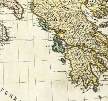
Maps can be among the most revealing documents in military history.
They show how rulers understood territory.
They identify roads, harbors, fortresses, mountains, rivers, and settlements.
During periods of war, maps become strategic tools.
For Venice, whose power depended heavily upon maritime communication, accurate charts and coastal maps were particularly important.
The idea of "lost Venetian maps" associated with the conquest of Ionian territories is therefore historically plausible in a general sense, although surviving collections already preserve substantial evidence of Venetian mapping.
Venice and the Eastern Mediterranean
The Republic of Venice developed an extensive maritime empire known as the Stato da mar.
Its territories and strategic interests stretched across the Adriatic, Ionian, and Aegean seas.
Venetian merchants and military forces required detailed geographical knowledge.
Maps were useful for:
navigation;
siege planning;
military logistics;
taxation;
administration;
coastal defense.
The Great Turkish War
One of the most important Venetian campaigns in the region occurred during the Great Turkish War of the late seventeenth century.
Venice attacked Ottoman territories after 1684.
The campaign produced major Venetian gains.
Lefkada was captured in 1684.
The Morea was conquered during the following years.
Venetian forces also operated along the Greek mainland and in other strategic regions.
The Royal Collection in Britain preserves a remarkable 1684 view of the Venetian siege of Lefkada's fortress of Santa Maura. The image depicts the Venetian fleet surrounding the Ottoman-held fortress and identifies individual ships.
Maps as Military Intelligence
A military map could show much more than geography.
It could identify:
artillery positions;
fortifications;
roads;
landing beaches;
anchorages;
troop movements.
The Royal Collection's 1684 depiction of the siege of Santa Maura is particularly valuable because it visualizes a specific military operation rather than simply representing the island geographically.
Coronelli and Venetian Cartography
The Venetian cartographer Vincenzo Coronelli produced maps and geographical works during the late seventeenth century.
His work included maps of territories involved in Venetian military campaigns.
A surviving 1687 map depicts Acarnania and the Epirote coast conquered by Venetian forces under Francesco Morosini in 1684.
This demonstrates that military mapping was closely connected to Venetian territorial expansion.
The Ionian Islands
The Ionian Islands were strategically important because they guarded maritime routes into the Adriatic.
Corfu was particularly important.
Lefkada, Kefalonia, Zakynthos, and other islands formed part of a broader maritime system.
Control over these islands allowed Venice to protect commercial and naval routes.
Why Some Maps Become "Lost"
Historical maps are fragile.
They can disappear through:
war;
private collection;
institutional reorganizations;
fire;
water damage;
dispersal of archives.
But "lost" can also mean something less dramatic.
A map may survive but remain unpublished.
It may exist in a private archive.
It may be catalogued under an unexpected name.
It may be misidentified.
Digital cataloguing has made some previously obscure cartographic material easier to discover.
Ottoman Geography Through Venetian Eyes
Venetian maps also reveal how Europeans perceived Ottoman territory.
A military map was not neutral.
The cartographer selected what mattered to the military operation.
A fortress might be exaggerated.
A coastline might be simplified.
Roads might be emphasized.
The map therefore provides information about both geography and strategic priorities.
Navigation and the Kitab-ı Bahriye
Venetian cartography existed alongside Ottoman and broader Mediterranean traditions of navigation.
The Sylvia Ioannou Foundation's digitized copy of the Kitab-ı Bahriye includes maps covering the Greek mainland, Peloponnese, Kythera, Zakynthos, Kefalonia, Lefkada, Corfu, and the Albanian coast.
This is important because it demonstrates that Mediterranean cartography was not exclusively a European enterprise.
Ottoman navigators also produced sophisticated geographic knowledge.
Maps and Conquest
A military campaign depended upon knowledge.
Commanders needed to know:
Where can ships land?
How strong is the fortress?
Where can artillery be positioned?
Which roads connect the coast to the interior?
Where can troops obtain water?
Which harbors are safe?
Maps helped transform geographical information into military planning.
The Morea Campaign
Venetian forces captured much of the Peloponnese during the 1680s.
This required coordination between naval and land forces.
The conquest of ports and fortresses was particularly important.
Maps could help commanders coordinate these operations.
The Fragility of Venetian Control
Venetian conquest did not guarantee permanent control.
The Ottoman-Venetian War of 1714–1718 reversed many Venetian gains.
The Ottomans reconquered the Morea.
This demonstrates why military maps are historically valuable.
They capture landscapes at particular moments of political change.
Conclusion
The idea of lost Venetian maps of the Ionian Sea is compelling because cartography was fundamental to Venetian military and maritime power.
Surviving materials already demonstrate the sophistication of this tradition.
The 1684 depiction of the siege of Santa Maura records the Venetian fleet and military positions.
Coronelli's maps document Venetian conquests along the Greek mainland and Epirote coast.
And Ottoman navigational traditions preserved parallel geographical knowledge across the same waters.
The search for additional maps is therefore not simply a hunt for beautiful historical documents.
Each map can reveal how states understood territory, planned warfare, controlled maritime routes, and transformed geography into political power.